Key resources:
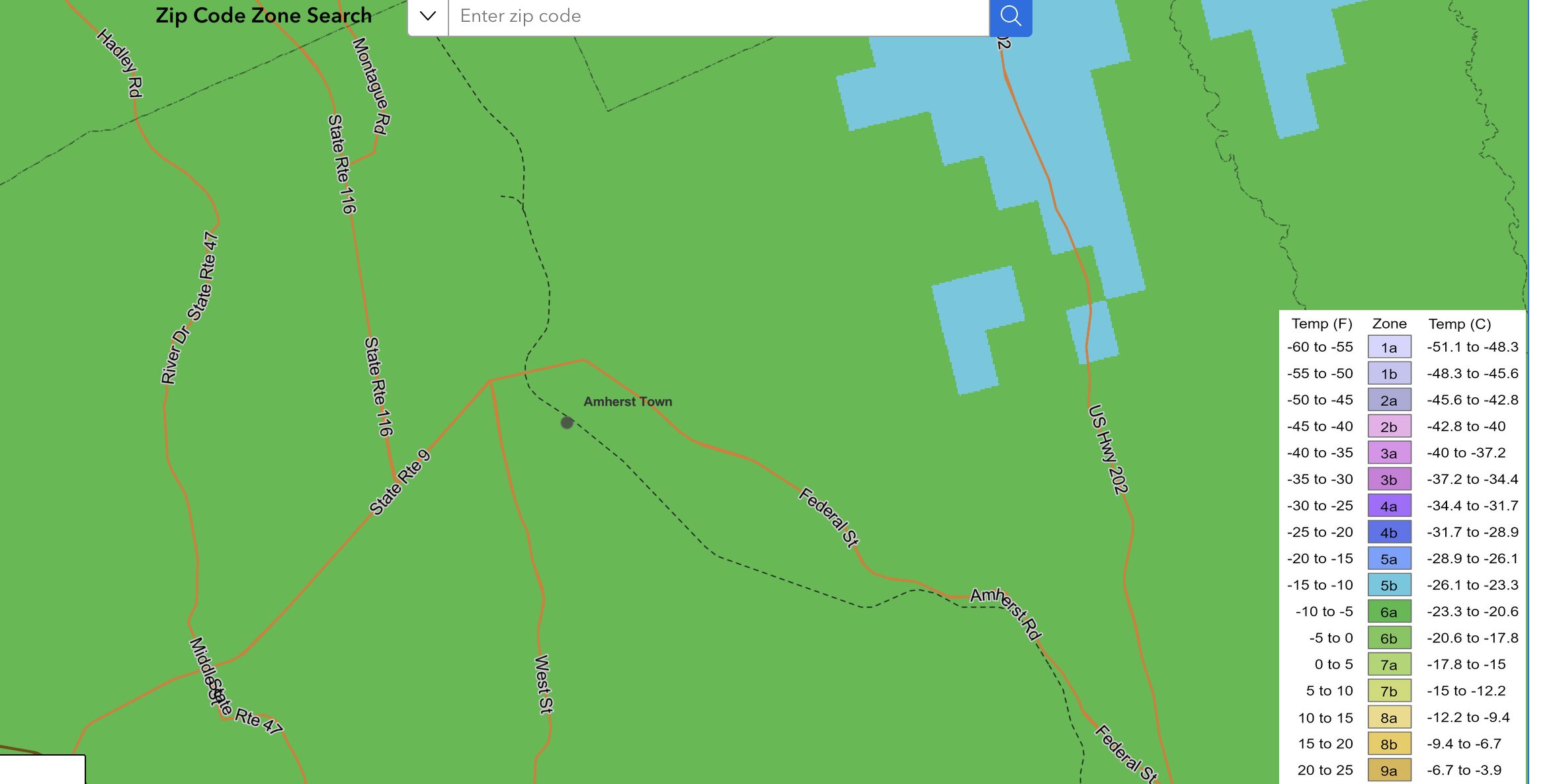
- USDA Plant Hardiness Zones – 6A
- USDA Soils Survey: 406B (close to 406A)
- Biota of North America (BONAP)
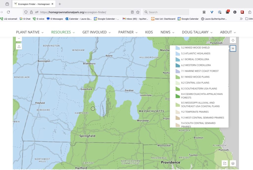
- EPA Ecoregions (8.1.7 Eastern Temperate Forests > Mixed Wood Plains > 8.1.7 Northeastern Coastal Zone) > Level 4 59a Connecticut Valley
- Elizabeth Ley, Selecting Plants for Pollinators: A Regional Guide for Farmers, Land Managers, and Gardeners in the Eastern Broadleaf, Oceanic Province, Including the States of Connecticut, New Jersey, Rhode Island and Parts of Delaware, Kentucky, Maine, Maryland, Massachusetts, New Hampshire, New York, Ohio, Pennsylvania, Tennessee (Pollinator Partnership & NAPPC 2007-ish) [pdf] [source at pollinator.org]
USDA Plant Hardiness Zone: 6A
USDA Plant Hardiness Zone Map: We are in zone 6A, but also close to 5B.
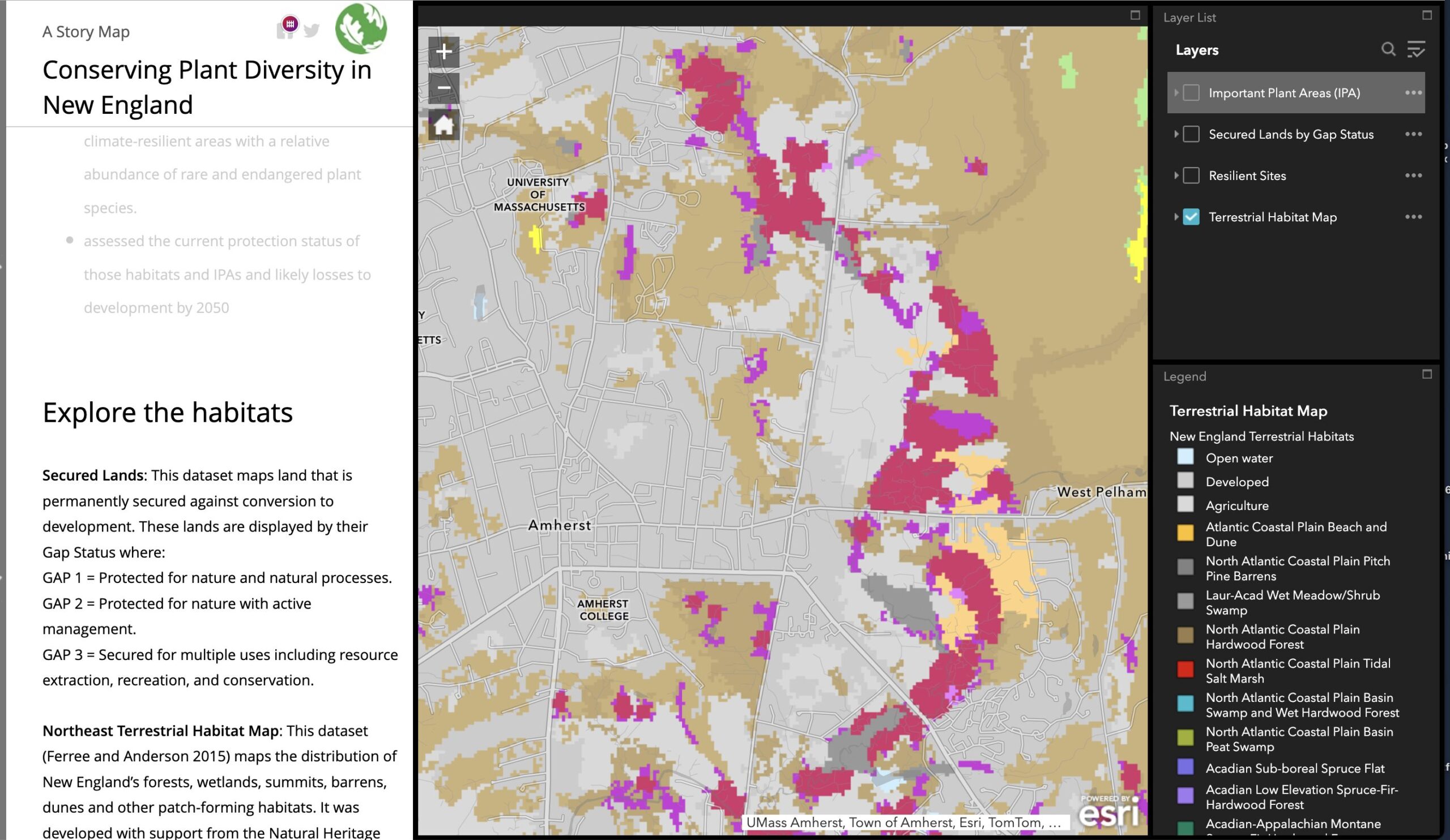
Habitat Type: Appalachian (Hemlock) – Northern Hardwood Forest
From the “Plant Diversity Report” — the mapping tool, available at Native Plant Trust — we are marked as grey, “developed”, but immediately adjacent is listed as Habitat Type: Appalachian (Hemlock)-Northern Hardwood Forest, in the Macrogroup: Northern Hardwood & Conifers.
Soils: 406B
Our soil is fairly acidic, which I imagine is included in the soil survey!
- USDA’s Web Soils Survey: 406B but also very close to 406A.
- USDA, Soil Conservation Service, in cooperation with Massachusetts Agricultural Experiment Station, Soil Survey of Hampshire County, Massachusetts, Central Part (Dec. 1981)
- Howard Reznik, Origins of the Soils of Western Massachusetts and the Pioneer Valley, Western Massachusetts Master Gardener Association, Condensed from “Roadside Geology of Massachusetts” By James w. Skehan, 2001 and from “Rhode Island Sustainable Gardening Manual” University of Rhode Island, 2006
- “According to the Soil Triangle, there are twelve different types of soil texture classes, with sand, clay, silt and loam being the four “pure” types, and the remaining eight combinations thereof. In western Massachusetts, 90% of our soil is sandy loam. The 10% in the Berkshires that is not sandy loam, is loam. We are more likely to find silt loam in the Valley, followed by loamy sand. ”
and
“New England soil tends to be acidic due to our R horizon (or parent material) being granite, and from acid rain. “– Joanne Lavengood, “Soil: A Primer“, Western Massachusetts Master Gardener Association
US EPA’s EcoRegion 8.1.7 59a
US EPA’s EcoRegions: 8.1.7 (Eastern Temperate Forests > Mixed Wood Plains > Northeastern Coastal Zone), 59a Northeastern Coastal Zone > Connecticut Valley.
101 Red Gate Lane is in Level 1 Ecoregion 8 “Eastern Temperate Forests”, but is very close to the boundary with Ecoregion 5 (Northern Forests) which dips down from Vermont & New Hampshire. The EPA ecoregion website has the ecoregion maps and map data, but not at a street-address level; HomegrownNationalPark maps addresses to Level II ecoregions, and that confirms that 101 Red Gate Lane is in 8 Eastern Temperate Forests > 8.1 Mixed Wood Plains. Level 3 is therefore 8.1.7, Northeastern Coastal Zone. There’s another set of maps that uses a different numbering system, and in that one, Level 3 is 59 Northeastern Coastal Zone and Level 4 is 59a Connecticut Valley.
- Level 1 Ecoregion: “North America has been divided into 15 broad, level I ecological regions. These highlight major ecological areas and provide the broad backdrop to the ecological mosaic of the continent, putting it in context at global or intercontinental scales.”
- 8 Eastern Temperate Forests
- 5 Northern Forests (dips down from Vermont / New Hampshire)
- Level 2 Ecoregions: “The 50 level II ecological regions that have been delineated are intended to provide a more detailed description of the large ecological areas nested within the level I regions. Level II ecological regions are useful for national and subcontinental overviews of ecological patterns.”
- 8.1 Mixed Wood Plains
- 5.3 Atlantic Highlands
- Level 3 Ecoregions: “Level III mapping describes smaller ecological areas nested within level II regions. At level III, the continent currently contains 182 ecological regions.”
- 8.1.7 Northeastern Coastal Zone
- 5.3.1 Northern Appalachian and Atlantic Maritime Highlands
- 59 Northeastern Coastal Zone
- 58 Northeastern Highlands
- Level 4 Ecoregions:
- 59a Connecticut Valley
- 58g Worcester / Monadnock Plateau (dips down from Vermont/New Hampshire)
Level 3 – 59. Northeastern Coastal Zone. “The Northeastern Coastal Zone ecoregion covers most of southern New England and the coastal areas of New Hampshire and southern Maine. Its landforms include irregular plains and plains with low to high hills. Appalachian oak forests and northeastern oak-pine forests are the natural vegetation types, with mostly mesic Inceptisol soils. Similar to the Northeastern Highlands (58), the Northeastern Coastal Zone contains relatively nutrient-poor soils and concentrations of continental glacial lakes, some of which are sensitive to acidification. This ecoregion, however, contains considerably less surface irregularity and greater concentrations of human population than Ecoregion 58. Although attempts were made to farm much of the Northeastern Coastal Zone after the region was settled by Europeans, land use now mainly consists of forests, woodlands, and urban and suburban development, with only some minor areas of pasture and cropland.” [EPA Level 4 map]
Level 4 Connecticut Valley ecosystem: “The Connecticut Valley of southern New England is a distinctive ecoregion where the boundaries are easily defined by bedrock geology and physiography. The topography is mostly level to rolling, with some higher hills. Although the dominant geology is sedimentary, such as arkose, siltstone, sandstone, shale, and conglomerate, tilted basalt layers have formed distinctive ridges in many parts of the valley. The Jurassic-age Holyoke basalt results in a prominent north-south trending ridge from southern Connecticut into central Massachusetts, which then curves to trend east-west in the Holyoke Range. Surficial geology deposits in the valley are relatively thick and include outwash, alluvial, and lake bottom deposits, in contrast to the mostly till deposits of adjacent ecoregions. With a climate milder than that found on surrounding uplands, and with relatively rich soils and level terrain, the valley has long attracted human settlement. Urban and suburban land cover is common, along with cropland and pasture, and deciduous forest mostly on the ridges. The forests contain central and transition hardwoods, and floodplain forests of silver maple and cottonwood occur. Surface water nutrients and alkalinity in the ecoregion are relatively high. A small disjunct area of the ecoregion occurs in the Pomperaug Valley of western Connecticut.” [EPA Level 4 map]